Category: Relationships Between Housing Business and Open Space
Read the Report on What makes housing accessible to everyday destinations in Southern California?
 Changes to the urban built environment have impacts on the social and ecological footprint of cities and regions long beyond their original planned lifespan. In particular, urban sustainability, transportation energy use, and community well-being and cohesiveness are largely determined by development decisions that led to the way our cities are arranged. This research explores the notion of urban accessibility, defined as the spatial separation between dwelling units and 32 types of destinations including shopping, open space, and public services. Using data on the roughly five million residential land parcels in Southern California, we use network analyses and multilevel regression modeling to determine what it is about homes that make them more or less accessible to a wide variety of destination types. In most places across the region, older homes, smaller homes, and multifamily residences have a positive relationship to accessibility; however this varies widely across counties and cities.
Download the full report here.
Explore the web app on the Relationships between Housing, Business and Open space
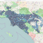 Click here for a web mapping application that allows you to explore the notion of urban accessibility, defined as the spatial separation between dwelling units and 32 types of destinations including shopping, open space, and public services for cities throughout Southern California. This application corresponds to MFI’s Quarterly Report “What makes housing accessible to everyday destinations in Southern California?”
Read published research on what makes housing accessible to everyday destinations in Southern California?
Publication:
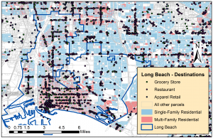
Kane, Kevin, John R. Hipp, and Jae Hong Kim. (2017). “Analyzing accessibility using parcel data: Is there still an access-space trade-off in Long Beach, California? The Professional Geographer 69:3, 486-503.
Abstract:
This article analyzes the impact of changing housing and neighborhood characteristics on the accessibility of neighborhood businesses using Long Beach, California, as a case study. Although advocates of smart growth and New Urbanism encourage land use mixing, aggregate-level analysis can be too coarse to pick up on fine-grained aspects of urban streetscapes. This study uses assessor parcel records and a point-based business establishment data set to analyze city-wide patterns of accessibility from individual dwelling units to thirty-one types of neighborhood businesses, including grocery stores, service shops, drug stores, doctor’s offices, and banks. Regression results compare parcel-level and neighborhood-level drivers of accessibility between 2006 and 2015 to gauge the aggregated effect of recent economic, demographic, and built environment changes on this aspect of urban spatial structure. Larger homes in older, multiunit buildings and higher income neighborhoods show substantial increases in accessibility to most establishment types, suggesting a trend toward both greater accessibility and larger dwelling units—despite the traditional trade-off between access and space. Although gradual increases in home and business density increased overall accessibility over this period, weaker neighborhood-level results indicate that this trend is less pronounced in high-poverty and non-white areas.